
Sar.png and Example: Advective Residual Transport of Salt in the Inner Außenweser: Difference between pages
From BAWiki
(Difference between pages)
imported>BAWiki 1 No edit summary |
imported>BAWiki 1 No edit summary |
||
| Line 1: | Line 1: | ||
[[de: Beispiel: Residueller advektiver Salztransport in der inneren Außenweser]] | |||
[[File:sar.png|frame]] | |||
Isosurfaces of equal advective residual transport of salt are shown for a period comprising several tidal cycles (mean value within the period of data analysis). Arrows are superpositioned. They indicate the mean direction of the (eulerian) residual transport. The residual advective transport of salt is closely related to the sum of the vectors for [[Example: Advective Flood Transport of Salt in the Inner Außenweser|advective flood transport of salt]] and for [[Example: Advective Ebb Transport of Salt in the Inner Außenweser|advective ebb transport of salt]]. Two phenomena can be clearly distinguished. At first there is a net transport of salt from the Jade Estuary (left edge of the figure) in northeast direction towards the Außenweser. Secondly along the deep channel (see [[Example: Bathymetry of the Inner Außenweser|bathymetry]]) two individual transport paths can be clearly distinguished. Along the western slope of the channel a landward residual transport of salt does occur whereas along the eastern slope a compensating seaward residual transport of salt can be found. There is strong evidence that this separation is mainly caused by the Coriolis force which acts to the right when looking in flow direction. Therefore the flood current follows the western slope of the channel whereas the ebb is shifted towards the eastern slope. | |||
[[Example: Bathymetry of the Inner Außenweser|Bathymetry]] for the area shown above | |||
---- | |||
back to [[Tidal Characteristic Numbers of Salinity]] | |||
Revision as of 07:22, 28 June 2010

Isosurfaces of equal advective residual transport of salt are shown for a period comprising several tidal cycles (mean value within the period of data analysis). Arrows are superpositioned. They indicate the mean direction of the (eulerian) residual transport. The residual advective transport of salt is closely related to the sum of the vectors for advective flood transport of salt and for advective ebb transport of salt. Two phenomena can be clearly distinguished. At first there is a net transport of salt from the Jade Estuary (left edge of the figure) in northeast direction towards the Außenweser. Secondly along the deep channel (see bathymetry) two individual transport paths can be clearly distinguished. Along the western slope of the channel a landward residual transport of salt does occur whereas along the eastern slope a compensating seaward residual transport of salt can be found. There is strong evidence that this separation is mainly caused by the Coriolis force which acts to the right when looking in flow direction. Therefore the flood current follows the western slope of the channel whereas the ebb is shifted towards the eastern slope.
Bathymetry for the area shown above
File history
Click on a date/time to view the file as it appeared at that time.
| Date/Time | Thumbnail | Dimensions | User | Comment | |
|---|---|---|---|---|---|
| current | 08:51, 25 September 2019 | 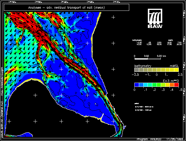 | 619 × 469 (285 KB) | Maintenance script (talk | contribs) |
You cannot overwrite this file.
File usage
The following page uses this file: