Ecological Connectivity - R&D Projects: Difference between revisions
From BAWiki
imported>Mueller-hagedorn No edit summary |
imported>Kampker Anne No edit summary |
||
| Line 1: | Line 1: | ||
[[de: Ökologische Durchgängigkeit - F+E-Projekte]] | [[de: Ökologische Durchgängigkeit - F+E-Projekte]] | ||
To solve connectivity questions regarding dimensions of stuctures and hydraulical topics BAW Section W1 and BfG Section U4 | |||
pursue their own research and development projects (R&D). These include several projects at BAW and/or BfG, cooperations with universities and a close network with national and international research institutions. | |||
Physical and hydronumerical modelling are employed. Ethohydraulical trials are executed in a relatively large research [[channel]]. The scientific findings of R&D projects will be more thoroughly investigated at projected pilot sites. R&D serve to assess the necessary dimensions of fish passes and to councel the German Waterways and Shipping Administration in their aim to achieve river connectivity. Results will be published in: | |||
* [http://www.baw.de/EN/service_wissen/publikationen/forschung_xpress/forschung_xpress.html?highlight=xpress%7C| BAW Forschung Xpress] | |||
* [http://www.baw.de/EN/wasserbau/forschung_entwicklung/forschung_entwicklung.html%7C| Research and Development] | |||
* [http://www.baw.de/EN/wasserbau/methoden/methoden.html| Methods] | |||
===Terminated R&D project=== | |||
[[File: Physikal-Modell-Lauffen.png|thumb|Physical model. Power plant tailwater Lauffen (River Neckar)]] | [[File: Physikal-Modell-Lauffen.png|thumb|Physical model. Power plant tailwater Lauffen (River Neckar)]] | ||
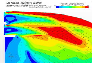
[[File: Geschwvert_Lauffen.png|thumb|Velocity distribution in the physical model. Power plant tailwater Lauffen (River Neckar)]] | [[File: Geschwvert_Lauffen.png|thumb|Velocity distribution in the physical model. Power plant tailwater Lauffen (River Neckar)]] | ||
A [[model]] of the tailwater of a power plant to the scale 1:10 was built, to help determine the [[attraction]] of a fishway located close to the hydro-electric plant. A location that is easily found by the fish is the first step towards the functioning of an upstream [[fish pass]] facility, but is probably also the most complex. The flow from the fish pass competes with that of the hydro-electric plant. The objective of the investigations was to create a migration corridor suitable for a wide range of fish species. This migration corridor should on average be existent 300 days per year under fluctuating discharges and tailwater levels. For attraction of fish in the corridor flow velocities are a crucial factor. The fish must be able to perceive the [[attraction flow]], but it must not fatigue them. | |||
The | Various discharges and different geometries of the entrance structure were studied to find an optimized configuration regarding the migration corridor. | ||
For interested members of the general public, a 3-D real time simulation was commissioned by the BAW to enable visualisation of the topic of upstream fish migration. This virtual fish pass has already been used successfully at public events. | For interested members of the general public, a 3-D real time simulation was commissioned by the BAW to enable visualisation of the topic of upstream fish migration. This virtual fish pass has already been used successfully at public events. | ||
Revision as of 10:21, 13 December 2017
To solve connectivity questions regarding dimensions of stuctures and hydraulical topics BAW Section W1 and BfG Section U4 pursue their own research and development projects (R&D). These include several projects at BAW and/or BfG, cooperations with universities and a close network with national and international research institutions.
Physical and hydronumerical modelling are employed. Ethohydraulical trials are executed in a relatively large research channel. The scientific findings of R&D projects will be more thoroughly investigated at projected pilot sites. R&D serve to assess the necessary dimensions of fish passes and to councel the German Waterways and Shipping Administration in their aim to achieve river connectivity. Results will be published in:
Terminated R&D project


A model of the tailwater of a power plant to the scale 1:10 was built, to help determine the attraction of a fishway located close to the hydro-electric plant. A location that is easily found by the fish is the first step towards the functioning of an upstream fish pass facility, but is probably also the most complex. The flow from the fish pass competes with that of the hydro-electric plant. The objective of the investigations was to create a migration corridor suitable for a wide range of fish species. This migration corridor should on average be existent 300 days per year under fluctuating discharges and tailwater levels. For attraction of fish in the corridor flow velocities are a crucial factor. The fish must be able to perceive the attraction flow, but it must not fatigue them. Various discharges and different geometries of the entrance structure were studied to find an optimized configuration regarding the migration corridor.
For interested members of the general public, a 3-D real time simulation was commissioned by the BAW to enable visualisation of the topic of upstream fish migration. This virtual fish pass has already been used successfully at public events.
Back to: Ecological Connectivity
