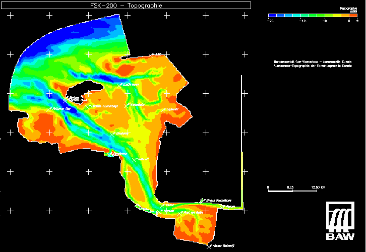
Example: Bathymetry of the Ems Estuary
From BAWiki
The figure shows the bathymetry for a numerical model of the Ems Estuary (Außenems) which includes in simplified form also the Unterems (right part of the figure).
The large on the bottom right is the Dollart area, which contains a large amount of tidal flats. The Dollart Bay is filled and emptied mainly through its central deep channel which is called Groote Gat. Towards the north the Dollart is separated from the Emder Fahrwasser (the access channel for ships towards the harbour of Emden) by means of a 10 km long dam (Geise-Leitdamm) which extends from west to east.
To the nothwest of the Dollart the estuary narrows and Emder Fahrwasser as well as Groote Gat merge in the area called Gatjebogen. From there towards the sea the estuary is split into two separate channels: one is the south lying Bucht von Watum and the other ist the north lying Ostfriesische Gatje.
Further towards the north these two separated channels are again united in the Dukegat. Towards the west they split again into two separate channels, the southern Alte Ems channel and the northern Randzelgat channel. Both channels pass through the cross section between the islands of Rottumeroog and Borkum. To the northwest of this cross section the Estuary opens towards the North Sea through the deep channels called Hubertgat and Westerems.
To the north of Ostfriesisches Gatje and near to the Dukegat the Osterems begins. This south-north running channel cuts through an area of tidal flats between the island of Borkum and the coastline. Further to the north the Osterems turns towards the west and passes a cross section between the island of Borkum and the islands of Memmert/Juist, where it begins to open towards the North Sea.
The dutch harbours of Eeemshaven and Delfzijl as well as the german harbour in the city of Emden are the most important ones in the Ems Estuary.
Significant inflow of fresh water into the Ems Estuary takes place through Eemskanaal, Termunterzijl, Nieuwe Statenzijl and the Unterems.

back to Characteristic Numbers of Water Level (independent of tides)
back to Characteristic Numbers of Salinity (independent of tides)
