Field Study Measurements: Difference between revisions
From BAWiki
imported>Juettner No edit summary |
The LinkTitles extension automatically added links to existing pages (<a target="_blank" rel="nofollow noreferrer noopener" class="external free" href="https://github.com/bovender/LinkTitles">https://github.com/bovender/LinkTitles</a>). |
||
| (7 intermediate revisions by 3 users not shown) | |||
| Line 1: | Line 1: | ||
[[File: Methoden_naturmessung_1.jpg|thumb|Picture 1: | [[de:Naturmessungen]] | ||
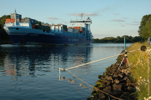
[[File: Methoden_naturmessung_2.jpg|thumb|Picture 2: | [[File: Methoden_naturmessung_1.jpg|thumb|Picture 1: Measurement of ship induced load on the banks of the Kiel Canal]] | ||
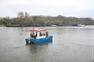
[[File: Methoden_naturmessung_3.jpg|thumb|Picture 3: | [[File: Methoden_naturmessung_2.jpg|thumb|Picture 2: Measurement of flow velocities in a groyne field during ship passing events]] | ||
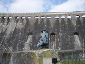
[[File: Methoden_naturmessung_4.jpg|thumb|Picture 4: | [[File: Methoden_naturmessung_3.jpg|thumb|Picture 3: Geodetic monitoring of Edersee dam]] | ||
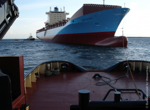
[[File: Methoden_naturmessung_5.jpg|thumb|Picture 5: | [[File: Methoden_naturmessung_4.jpg|thumb|Picture 4: Measurement of ship dynamics during the transfer of a yard newbuilding]] | ||
[[File: Methoden_naturmessung_5.jpg|thumb|Picture 5: Deployment of an ADCP mooring in the German Bight]] | |||
Special field studies are carried out in order to obtain generally high quality data for calibration and validation of the implemented model and computation methods, thus enhancing their accuracy and forecasting ability. Field study measurements are used primarily to determine | Special field studies are carried out in order to obtain generally high quality data for [[calibration]] and validation of the implemented [[model]] and computation methods, thus enhancing their accuracy and forecasting ability. Field study measurements are used primarily to determine | ||
* special water-related physical processes in the inland waterways and sea port approaches including the German coast (hydraulic measurements, e.g. for the dynamics of turbulence and suspended particles) | * special water-related physical processes in the inland waterways and sea [[port]] approaches including the German coast (hydraulic measurements, e.g. for the dynamics of turbulence and suspended particles) | ||
* vessel navigational dynamic parameters when passing through channels (navigational dynamic measurements) | * vessel navigational dynamic parameters when passing through channels (navigational dynamic measurements) | ||
* hydraulic loading (water level, current, wind-waves, ship waves) of structures in and on the waterway | * hydraulic loading ([[water level]], current, wind-waves, ship waves) of structures in and on the [[waterway]] | ||
with the results flowing directly into research and development and project work. | with the results flowing directly into research and development and project work. | ||
Navigational dynamic measurements are used for rating the vessel dynamic parameters such as position and location, squat, trim, propeller speed and rudder angle. These are then used to derive among others the course axes, space requirement and position of the actual pivotal point. The measurement data are used to validate navigational dynamic model procedures; they are also needed as input data for special tests in the context of ship handling simulation at the ship handling simulator. | Navigational dynamic measurements are used for rating the vessel dynamic parameters such as position and location, squat, [[trim]], propeller speed and rudder angle. These are then used to derive among others the [[course]] axes, space requirement and position of the actual pivotal point. The measurement data are used to validate navigational dynamic [[model]] procedures; they are also needed as input data for special tests in the context of [[Ship Handling Simulation|ship handling simulation]] at the [[ship handling simulator]]. | ||
Hydraulic measurements record characteristic physical processes pertaining to the waterway in high temporal and spatial resolution. Special combinations of standard sensors in innovative measurement concepts permit the use of ADCP, multi water sampler and multi-frequency echo sounder for measuring transport processes and the dynamics of suspended matter, in addition to conventional water level and current measurements. The data are used primarily for validation of hydro-dynamic numerical models in projects and research. | Hydraulic measurements record characteristic physical processes pertaining to the [[waterway]] in high temporal and spatial resolution. Special combinations of standard sensors in innovative measurement concepts permit the use of ADCP, multi water sampler and multi-frequency echo sounder for measuring transport processes and the dynamics of suspended matter, in addition to conventional [[water level]] and current measurements. The data are used primarily for validation of hydro-dynamic numerical models in projects and research. | ||
The BAW operates its own measurement boat for corresponding studies on inland waterways. | The BAW operates its own measurement boat for corresponding studies on inland waterways. | ||
When passing through the channels, water crafts generate a system of short- and long-period fluctuation in the water level (ship waves) that reach the adjoining banks and induce loading on the existing bank structures, such as rip-rap. The magnitude of the ship-induced waves depends primarily on vessel size (submerged main section), speed through the water, distance to the bank and the cross-section geometry of the waterway itself. Additional factors from swell and surge are significant in coastal areas and have to be considered accordingly in the concept drawn up for specific field studies. | When passing through the channels, water crafts generate a system of short- and long-period fluctuation in the [[water level]] (ship waves) that reach the adjoining banks and induce loading on the existing [[bank]] structures, such as rip-rap. The magnitude of the ship-induced waves depends primarily on vessel size (submerged main section), speed through the water, distance to the [[bank]] and the [[cross-section]] geometry of the [[waterway]] itself. Additional factors from [[swell]] and surge are significant in coastal areas and have to be considered accordingly in the concept drawn up for specific field studies. | ||
* [[Coastal Areas and Estuaries]] | * [[Field Study Measurements: Coastal Areas and Estuaries|Coastal Areas and Estuaries]] | ||
<br /> | |||
---- | ---- | ||
Latest revision as of 09:12, 21 October 2022
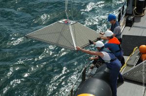
Special field studies are carried out in order to obtain generally high quality data for calibration and validation of the implemented model and computation methods, thus enhancing their accuracy and forecasting ability. Field study measurements are used primarily to determine
- special water-related physical processes in the inland waterways and sea port approaches including the German coast (hydraulic measurements, e.g. for the dynamics of turbulence and suspended particles)
- vessel navigational dynamic parameters when passing through channels (navigational dynamic measurements)
- hydraulic loading (water level, current, wind-waves, ship waves) of structures in and on the waterway
with the results flowing directly into research and development and project work.
Navigational dynamic measurements are used for rating the vessel dynamic parameters such as position and location, squat, trim, propeller speed and rudder angle. These are then used to derive among others the course axes, space requirement and position of the actual pivotal point. The measurement data are used to validate navigational dynamic model procedures; they are also needed as input data for special tests in the context of ship handling simulation at the ship handling simulator.
Hydraulic measurements record characteristic physical processes pertaining to the waterway in high temporal and spatial resolution. Special combinations of standard sensors in innovative measurement concepts permit the use of ADCP, multi water sampler and multi-frequency echo sounder for measuring transport processes and the dynamics of suspended matter, in addition to conventional water level and current measurements. The data are used primarily for validation of hydro-dynamic numerical models in projects and research.
The BAW operates its own measurement boat for corresponding studies on inland waterways.
When passing through the channels, water crafts generate a system of short- and long-period fluctuation in the water level (ship waves) that reach the adjoining banks and induce loading on the existing bank structures, such as rip-rap. The magnitude of the ship-induced waves depends primarily on vessel size (submerged main section), speed through the water, distance to the bank and the cross-section geometry of the waterway itself. Additional factors from swell and surge are significant in coastal areas and have to be considered accordingly in the concept drawn up for specific field studies.
back to Hydraulic Engineering Methods
